What the Nepal–China Border Flash Flood Reveals About Cascading Mountain Flood Risk
A technical perspective on a border-region disaster—and why early warning systems in steep terrain must account for more than rainfall.
A destructive flash flood in the Nepal–China border region severely affected the Rasuwa–Rasuwagadhi/Gyirong corridor and downstream river systems. The emerging interpretation points to a cascading mountain hazard rather than a conventional rainfall-only flood.
Investigations continue, and the precise initiation and routing mechanisms remain subject to revision. A plausible sequence begins with a high-elevation ice-rock collapse or avalanche entering the Lhende Khola headwaters. The mass movement may then have transformed into a debris-laden surge and propagated rapidly toward the Bhote Koshi and Trishuli river systems, carrying water, sediment, and large boulders into transport, settlement, utility, and border-infrastructure corridors.
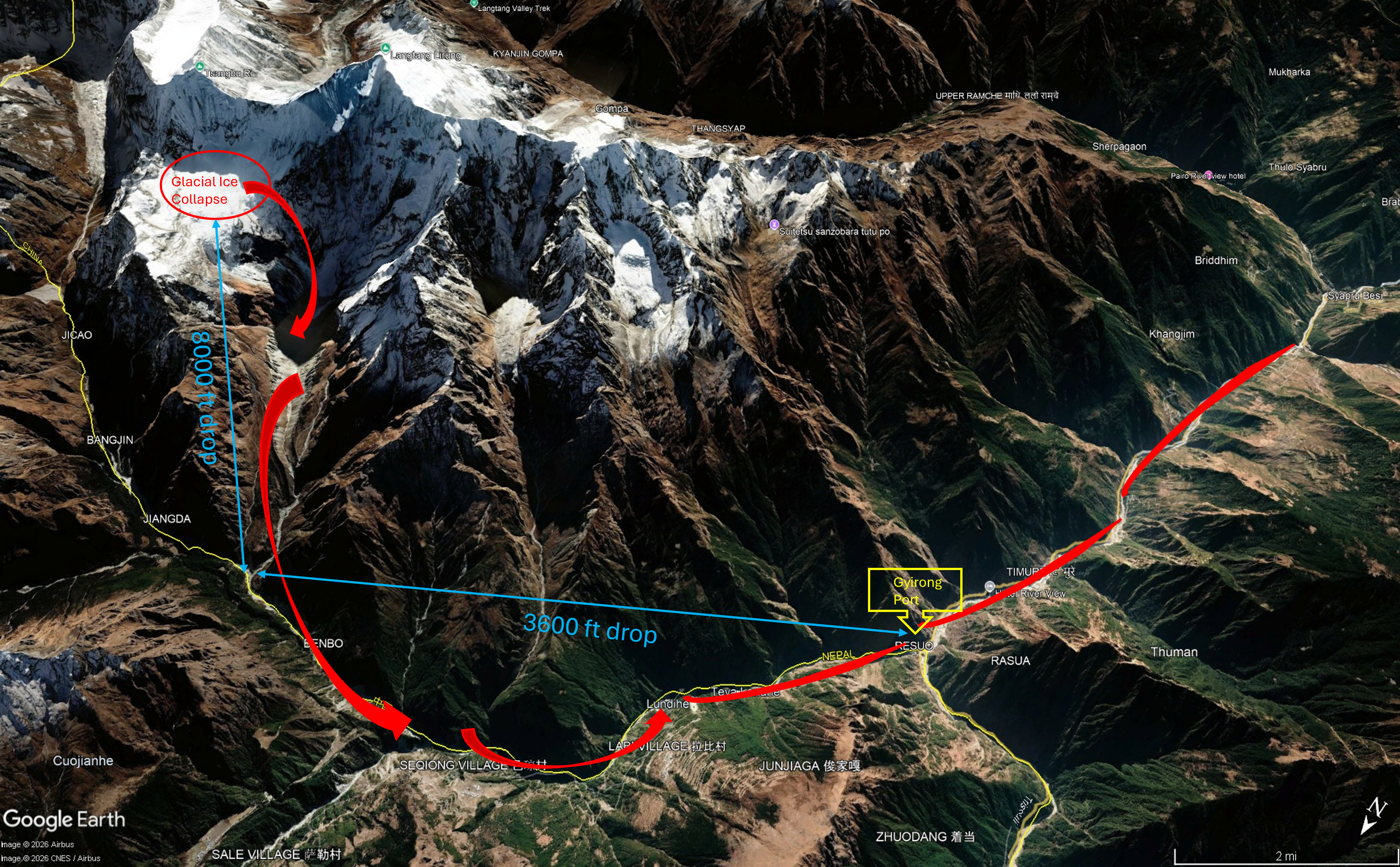
A likely cascade, not a single trigger
Mountain flood hazards often evolve across process domains. A cryosphere or slope failure can become an avalanche, entrain loose sediment, obstruct a channel, form a temporary impoundment, breach suddenly, and arrive downstream as a debris flood. Each transition changes the volume, momentum, sediment concentration, and destructive potential of the flow.
The warning problem is therefore not simply “Will it rain?” It is “What upstream process could create a damaging downstream wave, how quickly could it travel, and what lies in its path?”
Flood risk is multi-factor
A robust alert system must connect hazard generation, flow propagation, and downstream consequences. Five groups of variables are especially important.
Precipitation
Real-time and forecast intensity, duration, storm footprint, convective nowcasting, and multi-day accumulation.
Season and climate
Monsoon evolution, snow and glacier melt, freeze–thaw cycles, antecedent soil moisture, and long-term cryosphere change.
Terrain and sediment
Slope, elevation drop, valley confinement, channel capacity, tributary junctions, landslide susceptibility, and sediment supply.
Real-time signals
River stage and discharge, upstream water-level trends, turbidity, remote cameras, satellite change detection, and seismic or geotechnical observations.
Exposure and vulnerability
Settlements, roads, bridges, border facilities, utilities, evacuation routes, and people with limited mobility or access to warnings.
These controls interact. Moderate rainfall can become consequential when a basin is saturated or a channel is blocked. A remote slope failure can become a regional emergency when a narrow valley efficiently routes the surge toward concentrated infrastructure. The same physical event can therefore produce very different outcomes depending on antecedent conditions and exposure.
Detection must extend into remote headwaters
In steep basins, short travel times limit the value of any single sensor. Monitoring should combine terrestrial observations with remote sensing and model-based interpretation. Upstream gauges can reveal anomalous stage changes; seismic signals may indicate mass movement; cameras can confirm channel conditions; and satellite imagery can identify glacier, slope, lake, or blockage changes where continuous field instrumentation is impractical.
The objective is not to wait for perfect attribution. Operational systems should be able to recognize an abnormal upstream condition, estimate credible downstream arrival windows and impact zones, and communicate uncertainty without delaying protective action.
Early warning must be end to end
A technically accurate forecast is only one component of an effective warning system. A people-centered system links four functions:
- Risk knowledge: map where cascading hazards can initiate, travel, and cause harm.
- Detection and forecasting: combine multi-sensor observations with rainfall, hydrologic, hydraulic, terrain, and runout models.
- Communication: issue trusted, redundant, timely, and actionable messages across borders and jurisdictions.
- Preparedness and response: define who closes roads, suspends border traffic, shuts down vulnerable assets, evacuates, and moves people to higher ground.
Rare events create a preparedness gap
Frequent flooding creates familiarity, however imperfect. Communities often recognize local cues and maintain informal response habits. In places where extreme flooding is rare, residents and institutions may underestimate onset speed, lack practiced evacuation routes, or design infrastructure around ordinary conditions. A low-frequency event can therefore become a high-consequence disaster.
Risk policy should explicitly include credible worst cases, not only historically common floods. Priority actions include targeted hazard mapping, scenario exercises, resilient infrastructure design, redundant communications, public education, and special planning for remote communities and critical transport corridors.
A cross-border governance challenge
Mountain watersheds do not follow administrative boundaries. An upstream process can occur far from the communities, roads, and facilities it ultimately affects. That makes real-time data sharing and coordinated protocols among scientific agencies, emergency managers, infrastructure operators, local authorities, and neighboring countries essential.
- Integrate weather, hydrology, cryosphere, geomorphology, and exposure data
- Monitor remote headwaters with complementary ground and satellite systems
- Precompute cascading-hazard scenarios, travel times, and impact zones
- Share observations and alert thresholds across agencies and borders
- Translate technical thresholds into specific protective actions
- Use post-event forensic analysis to update models, maps, and protocols
From hazard detection to public action
The central lesson is straightforward: mountain floods should not be treated as simple rainfall problems. They emerge from interacting climate, cryosphere, slope, channel, sediment, hydrologic, and human systems. Resilience therefore requires multi-hazard monitoring, impact-based forecasting, and practiced public response—especially where a rare but severe flood could arrive with little warning.